
Monday, October 31, 2011
Federal 15th Corps
Sunday, October 30, 2011
Summers House

Thursday, October 27, 2011
Kennesaw Depot
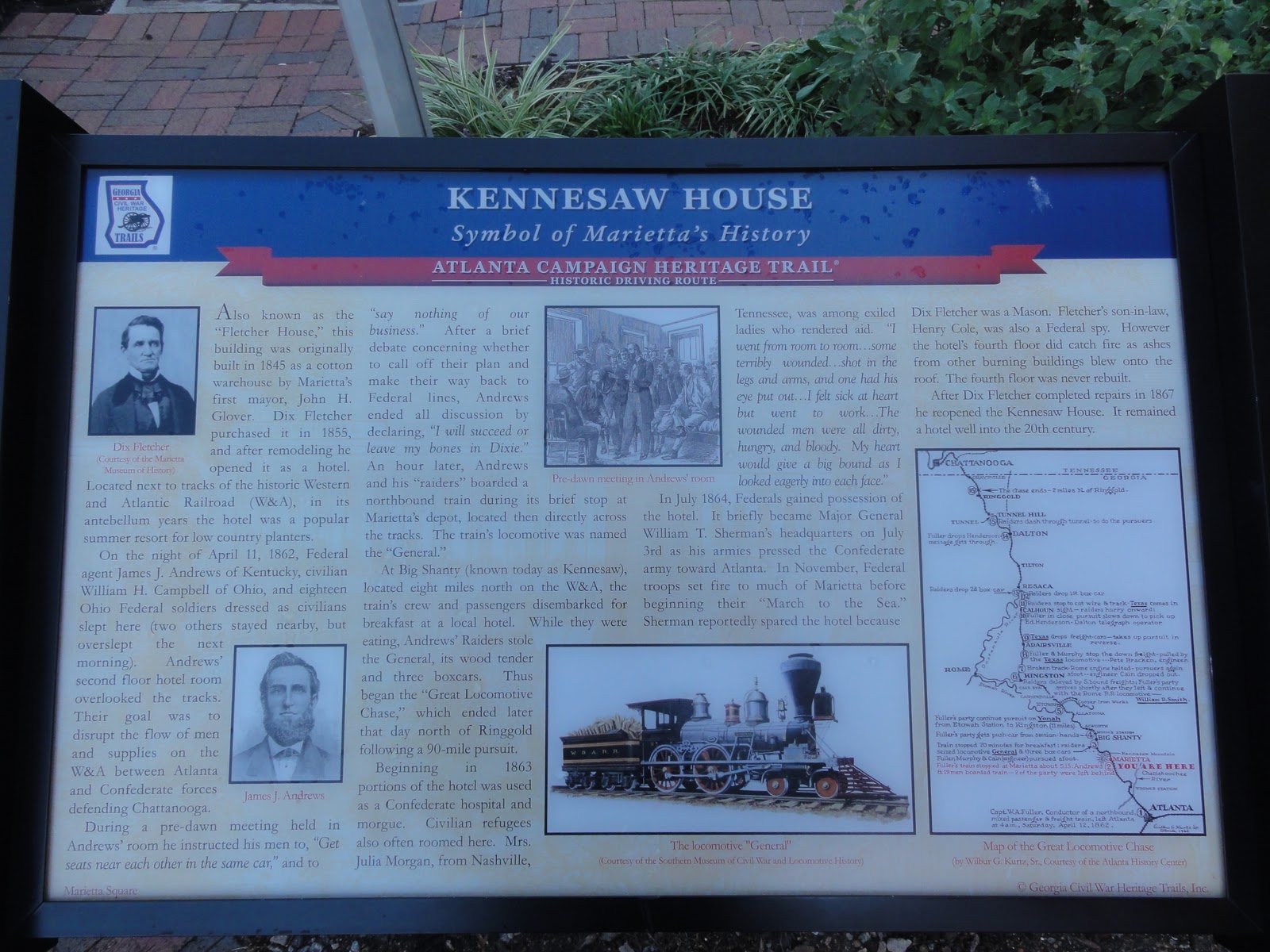
Built in 1908 by the Nashville, Chattanooga & St. Louis Railway. Currently houses several displays of local history.

DIRECTIONS: 34.023249,-84.614586 Located in downtown Kennesaw just off the corner of Cherokee Street and Main Street. Across the street from the Southern Museum of Civil War & Locomotive History.
Tuesday, October 25, 2011
Moon's Station


Monday, October 24, 2011
Gen. Leonidas Polk's Headquarters
 |
| Hardage House |

Kennesaw Spur

Friday, October 21, 2011
4th Corps Posted Along the River

Akers Mill
Akers Mill is located in the West Palisades Area of the Chattahoochee River National Recreation Area. The first 2 pictures were taken in 2003 prior to the building of the Rottenwood Creek/Bob Callan Trails. The last picture was taken towards the mill location from the Trail.
LOCATION: N 33°53.169 W 084°27.246 West Palisades Area of the Chattahoochee River National Recreation Area
 |
| Akers Mill from 2003 |
 |
| Akers Mill from 2003 |
 |
| On the Bob Callan/Rottenwood Creek Trail headed towards Akers Mill |
 |
| Looking towards Akers Mill from the Rottenwood Creek Trail. |
Vinings Pavilion

In the mid-1940's Hardy Pace's great-great granddaughter Earle Carter Smith bought the Pavilion. Windows were added and the Pavilion served as home to Atlanta's finest antique dealers until the Vinings Historic Preservation Society rescued it from destruction in 1995. In 1996, the Pavilion was moved to its current location alongside the Pace House. (Information from Vinings Historic Preservation Society)
LOCATION: N 33°51.997 W 084°27.864 Located in downtown Vinings.
Hardy Pace's House


This historic house was built with the remains of the 17-room antebellum home of Vinings founder Hardy Pace. The house served as General Sherman's temporary headquarters where he planned the siege of Atlanta. Hardy's son, Solomon Pace, returned home after the Civil War to find the home in ruins. Sometime between 1865 and 1874, Solomon painstakingly rebuilt the home—albeit more modestly—from doors, windows and remnants of several small cabins that survived the fire of the main house. (Information from Vinings Historic Preservation Society)
LOCATION: N 33°51.997 W 084°27.864 Located in downtown Vinings.
4th Corps at Vinings Station


Thursday, October 20, 2011
Big Shanty Spring


Tuesday, October 18, 2011
Camp McDonald

Friday, October 14, 2011


Cobb County

Glover Machine Works Locomotive


LOCATION:
33.953038 -84.551339 In downtown Marietta on Mill Street across the tracks from the Marietta Welcome Center.
Marietta Museum of History


Cherokee Indian Trail Tree


LOCATION: 33.967797 -84.563355 From Kennesaw Mountain take Kennesaw Avenue South. Turn right on St. Annes Road just past Tower Road. The tree is a short distance down on the left.
Thursday, October 13, 2011
Memorial Park - Kennesaw


Southern Museum of Civil War and Locomotive History


Subscribe to:
Comments (Atom)